Seven hundred people in Borroloola are being forced to shelter in place as a Category 3 cyclone approaches, with evacuation plans cancelled last minute amid intensifying weather.
Tropical Cyclone Megan is expected to hit the remote town between 3.30pm and 9.30pm on Monday.
At 1.30pm Chief Minister Eva Lawler announced the evacuation had been suspended due to Australian Defence Force planes being unable to land safely.
“We’re working with the local emergency management team to keep the community safe,” she said.
“There are enough buildings in Borroloola that are rated to withstand a Category 3 cyclone to keep the community safe.
“These include the police station, the health centre and dozens of homes in the community.
There are between 50 and 71 buildings in Borroloola graded to withstand a Category 3 cyclone, according to emergency services.
Earlier on Monday Ms Lawler insisted the evacuations had not come too late, with Darwin’s Foskey Pavillion set up to house the evacuees.
Emergency Services Minister Brent Potter said it was a decision of the pilots on the ground not to fly, and another evacuation attempt would be made on Monday night or Tuesday morning once the cyclone had passed.
“Or, if it’s safe to do so, we’ll keep those people there and bring supplies into Borroloola,” he said.
“Unfortunately, these things are dynamic and fluid and the cyclone has moved faster than we initially anticipated.”
Barkly MLA Steve Edgington said he had heard from local residents who felt they should have been evacuated over the weekend.
“Not this morning,” he said, citing food shortages and confusion on the ground.
“At the moment what we have is a large number of frustrated people in Borroloola who are concerned for their welfare.”
He said hundreds had gathered at the council offices adjacent to the airport waiting for a plane to land, and there were about 240 medically vulnerable residents who remained stranded in the community.
Half-built shelter angers locals
Funding for a $7m cyclone shelter in Borroloola was committed in 2021, with initial estimates it would be completed in 2022.
The Roper Gulf council provided an update on the project in October 2023 to say “works are progressing well” and a new finish date was set for February 8 this year.
However the structure remains under construction, something Mr Edgington said was “a real sticking point” for local residents.
Former chief minister Shane Stone said it was “a disgrace” there was no shelter in the community.
Mr Potter said the government wanted to see cyclone shelters in all remote communities and the one at Borroloola would be completed by the end of the year.
‘A worrying time’
Mayor Tony Jack told the ABC council staff and emergency services on the ground were helping residents to shelter, and it was “a worrying time” for all.
Borroloola was cut off for three weeks when Cyclone Lincoln hit last month, with much of the region still saturated from recent storms.
Providing an update at 2.30pm on Monday, Incident Controller Superintendent Sonia Kennon said it was not safe for Borroloola residents to attempt to leave by themselves and asked people not to drive out of the community.
She said it was expected conditions would have eased considerably by Tuesday morning.
“It will still be very important to await advice from emergency services to ensure that there hasn’t been any damage in the community before leaving any of your safe locations, but really the overnight period tonight is the time which is going to be the wettest, the windiest and the most uncomfortable,” she said.
“We are just reminding everybody to enact your household emergency plan now.”
March 18, 12.30pm: The Incident Controller at 12.20pm has warned the use of Australian Defence Force aircraft to evacuate the town was being hampered by worsening weather conditions.
They said the aircraft was still attempting to land and would remain in the area until 12.30pm.
“If the aircraft land, passengers will be conveyed from Borroloola to the McArthur River Mine then transferred to a larger aircraft for onwards transfer,” they said.
“The most vulnerable people will be transferred as a priority.
“Alternatively, if the aircraft continue to be prevented by the prevailing weather conditions, and cannot make a safe landing, the aircraft will remain within the Northern Territory to provide assistance if required after Tropical Cyclone Megan has passed.”
NT Police Assistant Commissioner Matt Hollamby said no injuries had been reported throughout the evacuation process.
Assistant Commissioner Hollamby said Groote Eylandt had also suffered substantial damage thanks to the intense rainfall of cyclone Megan.
The Bureau of Meteorology on Sunday said the region had recorded up to 500mm of rain in a 24-hour period.
“There was a ship that has severely damaged the port at Groote Eylandt,” Assistant Commissioner Hollamby said.
“The Australian Maritime Safety Authority is managing that incident.
“We can also say the power is out and vehicular traffic between Angurugu and Alyangula is limited.”
March 18, 8.45am: Evacuations have begun after Tropical Cyclone Megan intensified to a category three storm on Sunday.
Senator Malarndirri McCarthy said Borroloola residents who wanted to leave the town for the duration of Cyclone Megan should report to the evacuation point at the Roper Gulf Council area.
Ms McCarthy said two planes would take evacuees from Borroloola to McArthur River Mines where two RAAF aircraft take them further north to Darwin.
“The elderly and vulnerable will go first,” she said in a statement.
“The RAAF aircraft will be making a number of trips so let NT Police know you would like to be on the evacuation list.”
Ms McCarthy said residents needed to pack a small carry-on bag of personal items including a small water bottle, wear closed in shoes, and recommended eating before the flight.
She told the ABC the evacuees would likely take refuge at the Darwin showgrounds.
A Gemco employee said Groote Eylandt and the neighbouring mine site had “received massive damage” after Tropical Cyclone Megan swept through.
He said Port Wharf had been “severely damaged” and speculated it could take months to repair, preventing ore from being loaded onto ships.
“The roads are damaged to an extensive level and no road trains will able to haul ore to the port for many months,” he said.
“The mine pits are all full of water and are unable to be pumped out due the loss of pumps, generators, et cetera.”
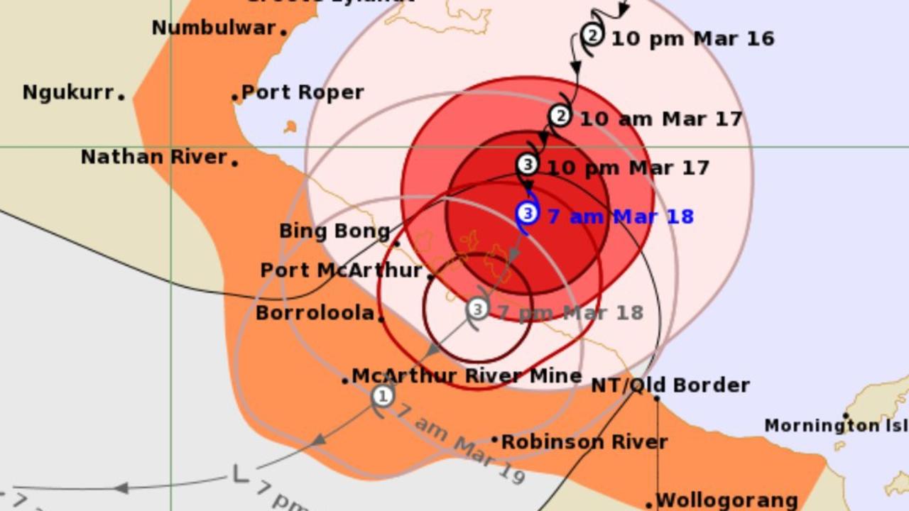
The Bureau of Meteorology said at 7.17am Monday the cyclone warning zone included Alyangula in the NT to Mornington Island in Qld – but not including Mornington Island – and extended inland to Borroloola, McArthur River Mine, and Robinson River, but did not include Ngukurr.
The Bureau said Megan’s “very destructive core” had wind gusts up to 200km per hour that were impacting the Sir Edward Pellew Group and would extend to nearby regions between Bing Bong and the NT/Queensland border throughout Monday.
The severe cyclone is moving south at 6km per hour and is expected to track west and weaken to a tropical low after it makes landfall.
In response to the heavy rainfall tropical cyclone Megan is expected to bring, there were 25 catchments on flood watch across the NT as of 12.03pm Sunday, including:
Mary River
Daly River above Douglas River
Katherine River
South Alligator River
Wild man River
Buckingham River
Goyder River
Blyth River
Liverpool River
Goomadeer River
East Alligator River
Koolatong River
Walker River
Groote Eylandt
Waterhouse River
Roper River
Towns River
Limmen Bight River
Rosie River
McArthur River
Robinson River
Calvert River
Settlement Creek
Nicholson River
Barkly
March 17, 4pm: Remote Territorians are being advised to consider self-relocating to avoid the worst of Tropical Cyclone Megan after the “severe” weather event intensified to a category three storm on Sunday.
Incident Controller Sonia Kennon said while there was no evacuation order in place for the affected communities – including Alyangula, Borroloola, McArthur River Mine, and Robinson River.
But Superintendent Kennon said self-extraction was “the preferable outcome”.
She said anyone who wished to relocate for the duration of the cyclone should report to their local police station to provide their contact details, vehicle registration and intended destination.
“This is to ensure that we can follow up on you and make sure that you advise whoever you’re going to go and stay with, that they’re aware that you’re coming so that if you do not arrive then they can make a call and contact police,” Superintendent Kennon said.
“We ask that if that is your choice, that you ensure that you are driving a capable vehicle as we understand there is slight damage to the Carpentaria Hwy.
“We recommend that you have a four-wheel drive vehicle if you are leaving the community.”
She urged anyone who chose to stay in the Cyclone Watch zones to ensure their cyclone kits were ready and their household and belongings were secured.
The Bureau of Meteorology’s Shenagh Gamble said there was a “moderate chance” the severe cyclone could intensify to category four.
“The Bureau of Meteorology is forecasting that severe Tropical Cyclone Megan will intensify – it is a low level category three tropical cyclone at the moment,” she said.
“Our current forecast is not that it will reach category four tropical cyclone.
“However, if this system slows down it is in a favourable enough environment that it can strengthen to a category for tropical cyclone.”
Ms Gamble said the severe cyclone was currently sustaining wind speeds of 120km per hour and gusts of 165km per hour.
She said Tropical Cyclone Megan had dumped about 400-500mm of rain over Groote Eylandt in a 24-hour period.
“The very destructive core of severe tropical cyclone Megan is expected to cross the coast during Monday and those very destructive winds will be gusting up to 220 kilometres per hour,” she said.
It is the first category three cyclone to make landfall in the NT since Tropical Cyclone Trevor in 2019.
More Coverage
Chief Minister Eva Lawler urged Territorians to stay safe in light of the dangerous weather conditions.
“Strong winds and a lot of rain is likely over coming days – and flash flooding is a possibility,” she said.
“We’re no strangers to cyclones and floods but we all should remember to take precautions and stay safe.”
https://news.google.com/rss/articles/CBMitQFodHRwczovL3d3dy5udG5ld3MuY29tLmF1L25ld3Mvbm9ydGhlcm4tdGVycml0b3J5L3dlYXRoZXIvY3ljbG9uZS1tZWdhbi1pbnRlbnNpZmllcy10by1jYXRlZ29yeS10aHJlZS1jb21tdW5pdHktc2VsZmV2YWN1YXRpb24tcHJlZmVyYWJsZS9uZXdzLXN0b3J5LzEwOWEwNTA1OWEyY2UyMzZjYjMxMjY5NmRhNTc0NzRl0gEA?oc=5
2024-03-18 08:24:28Z
CBMitQFodHRwczovL3d3dy5udG5ld3MuY29tLmF1L25ld3Mvbm9ydGhlcm4tdGVycml0b3J5L3dlYXRoZXIvY3ljbG9uZS1tZWdhbi1pbnRlbnNpZmllcy10by1jYXRlZ29yeS10aHJlZS1jb21tdW5pdHktc2VsZmV2YWN1YXRpb24tcHJlZmVyYWJsZS9uZXdzLXN0b3J5LzEwOWEwNTA1OWEyY2UyMzZjYjMxMjY5NmRhNTc0NzRl0gEA
Bagikan Berita Ini


0 Response to "Cyclone Megan intensifies to category three, Borroloola evacuations begin - NT News"
Post a Comment