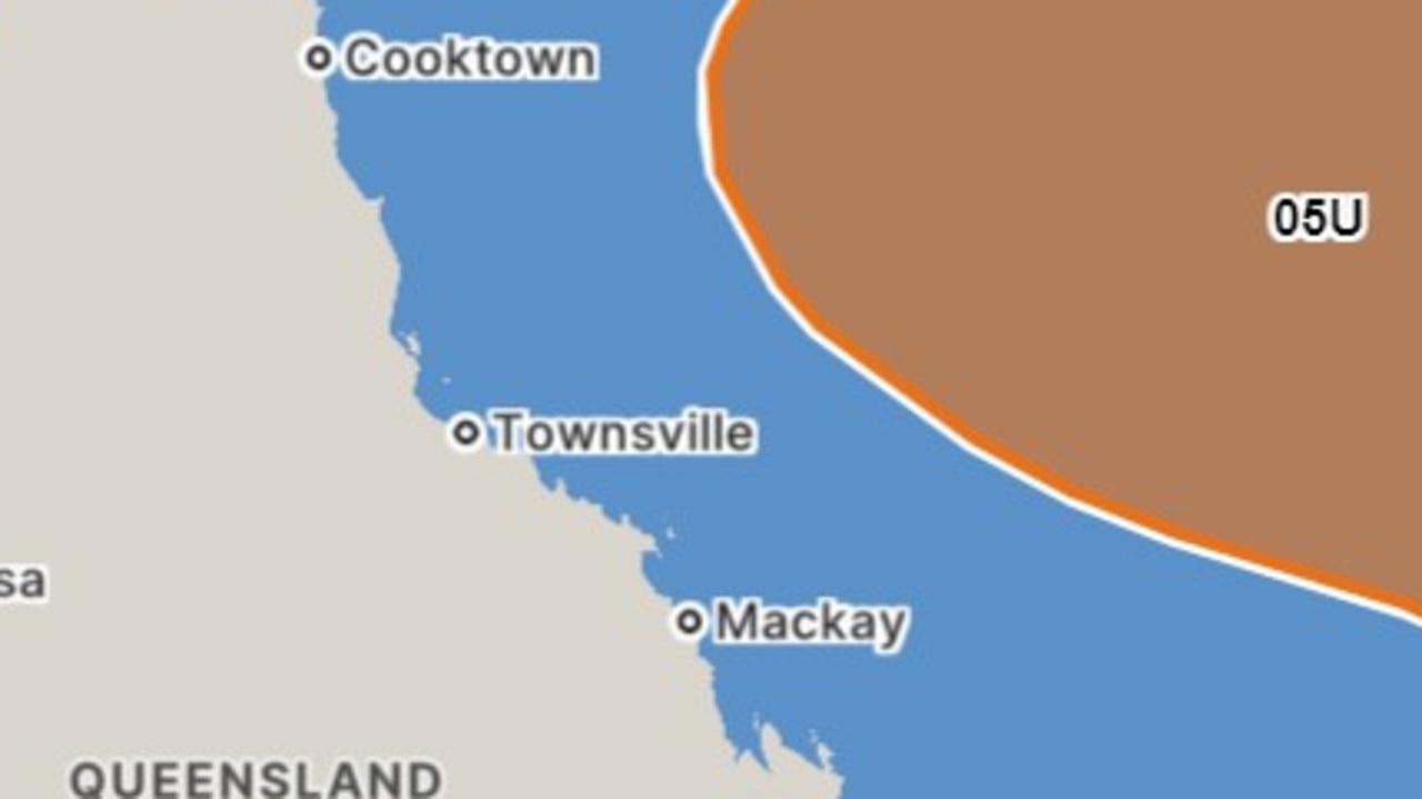
Far North Queensland is bracing for the high chance another cyclone could strike the coast as early as next week.
A tropical low currently formed in the Coral Sea is expected to develop into a cyclone by Monday.
The Bureau of Meteorology has forecast there is a “significant risk” the system will develop by 75 per cent chance on Monday before increasing the probability to 85 per cent on Tuesday and Wednesday.
“Uncertainty remains high with movement of this system, a coastal crossing remains possible,” the Bureau stated on Thursday.
The tropical low is expected to strengthen during the weekend and become a tropical cyclone by Monday.
“The low will initially be slow moving then move on a general southerly track from Sunday to Tuesday,” the BOM said.
“Its movement then becomes uncertain but likely to come towards the coast.
“There is a significant risk that this system may impact the Queensland coast from later Tuesday onwards next week.
“A severe impact is possible.”
The looming threat will put communities on the east coast of Queensland on high alert, as thousands of residents still recover from the aftermath of ex-Tropical Cyclone Jasper in late December.
It comes as the east continues to feel the effects of El Nino conditions across the summer, despite this summer being “somewhat unusual”.
“There is no real typical El Nino as no two El Ninos are the same,” meteorologist Andrea Pearce said.
“We are still in El Nino and this is because surface temperatures are still meeting the right criteria, although atmospheric conditions have weakened recently.
“El Nino is known to affect the weather in certain ways but there is no guarantee of those affects especially when so many other factors are at play.
“This summer we’ve seen very high sea surface temperatures in the Tasman Sea, several degrees warmer than usual, and this has likely contributed to the increased wet weather.”
Ms Pearce said a positive Southern Annual Mode – or SAM – was also influencing weather conditions.
“When active during summer, SAM has historically increased the chance of above average rainfall in parts of the east,’ she said.
Meanwhile, warm, humid and stormy conditions are forecast for large parts of Queensland and northeast NSW for Thursday.
“Severe storms are expected, with heavy rainfall, flash flooding, damaging winds, and large hail also possible,” the Bureau forecast.
“A trough is moving into Northeast NSW with a moist tropical air mass in place.
“Thunderstorms have formed this afternoon and should continue to develop and spread further east throughout the day.”
Severe thunderstorms are likely to produce heavy rainfall that may lead to flash flooding in the following areas:
- Armidale
- Glen Innes
- Inverell
- Tamworth
- Gunnedah
- Dorrigo
A severe thunderstorm warning has also been issued for the Maranoa and Warrego and Darling Downs including Roma, Charleville, Goondiwindi, Mitchell, Inglewood and Tara in Queensland.
“Heavy rainfall leading to flash flooding and damaging winds are possible over the coming hours,” the Bureau warned.
Westerly winds of 30 to 45 km per hour are also forecast for the Melbourne area, with a high chance of showers in the southeast suburbs, medium chance elsewhere.
The city can expect to reach a high of 21 degrees on Thursday.
Sydney remains mostly sunny with light winds and a top of 30 degrees, while Adelaide will reach a maximum temperature of 24 degrees.
https://news.google.com/rss/articles/CBMisAFodHRwczovL3d3dy5uZXdzLmNvbS5hdS9icmVha2luZy1uZXdzL3Ryb3BpY2FsLWxvdy1mb3Jtcy1vZmYtZmFyLW5vcnRoLXF1ZWVuc2xhbmQtd2l0aC1ib20td2FybmluZy1hLWN5Y2xvbmUtY291bGQtZm9ybS1ieS1uZXh0LXdlZWsvbmV3cy1zdG9yeS9mOTVjNmFhODEwMGQzODcwYWEzYTllNjI1ZTkwY2NiZdIBtAFodHRwczovL3d3dy5uZXdzLmNvbS5hdS9icmVha2luZy1uZXdzL3Ryb3BpY2FsLWxvdy1mb3Jtcy1vZmYtZmFyLW5vcnRoLXF1ZWVuc2xhbmQtd2l0aC1ib20td2FybmluZy1hLWN5Y2xvbmUtY291bGQtZm9ybS1ieS1uZXh0LXdlZWsvbmV3cy1zdG9yeS9mOTVjNmFhODEwMGQzODcwYWEzYTllNjI1ZTkwY2NiZT9hbXA?oc=5
2024-01-18 20:13:45Z
CBMisAFodHRwczovL3d3dy5uZXdzLmNvbS5hdS9icmVha2luZy1uZXdzL3Ryb3BpY2FsLWxvdy1mb3Jtcy1vZmYtZmFyLW5vcnRoLXF1ZWVuc2xhbmQtd2l0aC1ib20td2FybmluZy1hLWN5Y2xvbmUtY291bGQtZm9ybS1ieS1uZXh0LXdlZWsvbmV3cy1zdG9yeS9mOTVjNmFhODEwMGQzODcwYWEzYTllNjI1ZTkwY2NiZdIBtAFodHRwczovL3d3dy5uZXdzLmNvbS5hdS9icmVha2luZy1uZXdzL3Ryb3BpY2FsLWxvdy1mb3Jtcy1vZmYtZmFyLW5vcnRoLXF1ZWVuc2xhbmQtd2l0aC1ib20td2FybmluZy1hLWN5Y2xvbmUtY291bGQtZm9ybS1ieS1uZXh0LXdlZWsvbmV3cy1zdG9yeS9mOTVjNmFhODEwMGQzODcwYWEzYTllNjI1ZTkwY2NiZT9hbXA
Bagikan Berita Ini


0 Response to "State on alert as cyclone threat intensifies - news.com.au"
Post a Comment