Key posts
Here’s a map and table of the latest major emergency warnings published by the SES. We’ll keep updating this throughout the evening, so keep refreshing the blog.
We’ll update them throughout the day. Please refresh your web browser to make sure you have the latest version:
Click here for more information.
Another rain-bearing weather system is likely to hit an already-sodden eastern Australia next week, bringing with it the chance of more flooding.
Weatherzone meteorologist Ben Domensino said modelling indicated that rain would return to flood-affected areas on Wednesday or Thursday.
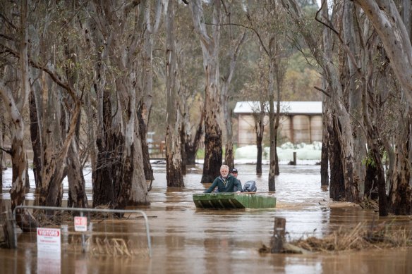
Craig Sherwood and Craig Watts return after taking hay to cattle stranded on a small patch of high ground in Seymour.Credit:Jason South
“At this stage, it’s not looking as heavy as this week’s rain has been,” Domensino said. “But – without wanting to cause any alarm – the landscape will be very sensitive to any more rain in the next week because of the amount of water that has fallen over the past two days.”
The slow-moving band of cloud that brought heavy rain and extensive flooding to Victoria this week has moved over the Tasman Sea. Some parts of the state received more than 200 millimetres – close to a season’s worth of rain – in just 48 hours.
VicEmergency has warned Echuca and Moama could face major flooding similar to the 1993 flood from late next week.
The early warning has come with a moderate flood warning for the Murray River downstream of the Hume Dam to Tocumwal.
It said this flood was expected to be higher than the 2016 flood and could possibly be similar or exceed the 1993 flood.
VicEmergency said:
Heavy rainfall overnight Thursday into Friday has resulted in rapid river level rises, and includes major flooding along the Goulburn and Campaspe Rivers
Flood operations are being conducted by the Murray-Darling Basin Authority (MDBA) at Hume Dam to manage inflows from the upper Murray, Mitta Mitta River and other tributaries.
MDBA are working closely with the Bureau and WaterNSW to plan release strategies.
VicEmergency said it expected to make its next update on Saturday at 4pm but for locals to keep a close eye on emergency warnings.
You can find out more at www.emergency.vic.gov.au
Lake Eildon’s spillway gates have opened for the first time since October 1996 due to the floods.
Goulburn Murray Water confirmed the release today, which is expected to continue for the coming days.
The Victoria Racing Club is coming under fire from angry Maribyrnong residents who are concerned about the impact of the flood wall the VRC built in 2007.
Former VRC chief executive and chairman of Harness Racing Victoria Dale Monteith took to social media to praise the flood wall on Friday posting “then and now” pictures of previous flooding at the racetrack.
“Took five years with the process and build,” he posted.
“Pretty happy that we have left a legacy for future of Flemington. Was always going to happen but ignored previously.”
However, local residents and social media users voiced their disapproval.
“Are you...actually bragging about building a wall that is currently redirecting flood water away from a natural flood plain and onto/into people’s streets and homes,” Abigail Lewis posted.
“Just like the residents you steamrolled at the time warned you it would?”
“Ah yeah as a resident of the area it’s so fantastic that the racecourse is fine while all the local roads are under a metre of water,” James Hutcheon posted.
In 2004 Melbourne, Maribyrnong and Moonee Valley councils warned the state government building the floodwall could cause houses near Flemington racetrack to be flooded.
Approving the project then planning minister Mary Delahunty said: “The flood protection works and racetrack upgrade will ensure that major horse racing events at Flemington, such as the Cup or the Victoria Derby, cannot be affected by major flooding of the Maribyrnong River.”
However, Maribyrnong councillor Bill Horrocks warned of the future impact on local residents.
“So when the inevitable happens and our community is knee-deep in water, we hope the minister is ready to take the heat,” he said at the time.
The VRC declined to comment.
Shepparton and Mooroopna residents have been told to prepare for evacuations as the Goulburn River could peak at 12 metres on Tuesday.
According to VicEmergency, a 12m high reading would be just below the 1974 flood which saw it peak at 12.09m.
VicEmergency put out its latest alert on Friday and emergency officials hosted a community meeting in Shepparton on Friday night.
Major flooding continues in Seymour and along the Acheron River, Yea River, Hughes Creek and Sunday Creek while minor flooding moved downstream to Shepparton on Friday morning and it is expected to rise to major flood levels on Saturday.
From VicEmergency:
The Goulburn River at Shepparton is currently at 9.36 metres and rising, below the minor flood level. The Goulburn River at Shepparton is expected to exceed the minor flood level (9.50 m) late Friday morning. The river level is expected to exceed the moderate flood level (10.70 m) early Saturday morning and is likely to exceed the major flood level (11.00 m) late Saturday morning. Further rises are likely, and the river level may reach around 12.0 metres during Tuesday, similar to the 1974 flood event level of 12.09 metre. Stay safe - avoid the flooded area.
Murchison resident Scotty Richter was coordinating sandbagging efforts for small businesses on the main street, with the help of several local schoolchildren, whose school day had been cut short by midmorning.
The Goulburn River was still a few hours away from peaking, but Richter said there was a good chance the shops would be spared. A levee was built to protect the town following a record flood in 1916.
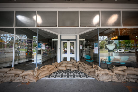
A Murchison shop surrounded by sandbags on Friday.Credit:Eddie Jim
“Hopefully, everyone along this street and downstream will be all right,” he said.
A number of houses just upstream on the eastern side of the bridge weren’t as fortunate and were already under water.
“Some houses were built in the wrong spot,” Richter said.
“With this sort of rain we’ve had recently, it [the river] just can’t keep up with it, so it’s got to go somewhere.
“Let’s hope they’re all safe and on high ground.“
Richter said many people in the town of 900 people were chipping in to help protect those in lower-lying areas.
The bakery, which had just been sandbagged, had handed out free pies to all of the volunteers.
The Mickleham quarantine facility is expected to re-open for use early next week as a crisis accommodation for people displaced by flooding.
“The Victorian and Commonwealth Governments have agreed to stand up the Mickleham quarantine facility for Victorians who may need crisis accommodation due to flooding,” a government spokesperson said.
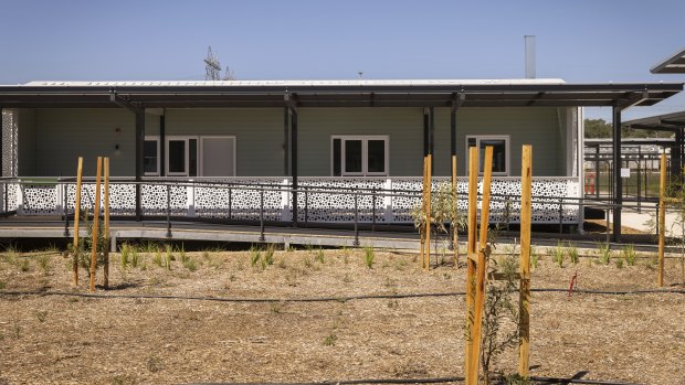
Guest rooms at the new quarantine hub in Mickleham earlier this year.Credit:Paul Jeffers
“Work has begun on preparations to reopen the site for use early next week.
“The facility will reopen with a capacity of 250 places for six to eight weeks, however, actual use will depend on the emergency response and accommodation demand.”
Werribee locals have gathered on either side of the Cottrell Street driving bridge which is now underwater.
Fast-flowing water has completely covered the road, which links the eastern and western parts of town over the Werribee River.

Locals take photos of the water surge along the Werribee River trail.Credit:Marta Pascual Juanola
Dallas Jackson and daughters Abigail and Hannah came down after school to see it.
“It’s something nice to come and see, it’s out of the ordinary,” Jackson said.
“We used to drive across this road and now it’s under two or three metres of water.”
Floodwater now covers most of the pole holding a give way sign.
The fencing on either side of the road has disappeared completely from sight.
“It looks fun. It looks like a rollercoaster,” Abigail said jokingly, about the prospect of swimming across the river.
“But I think when I reach halfway, it’ll probably, like, swish me away.”
Murchison police dropped Troy Leay off at their local station this afternoon.
With him were his two dogs, Diesel and Ripper, and two large bags stuffed with clothing and a few other possessions.
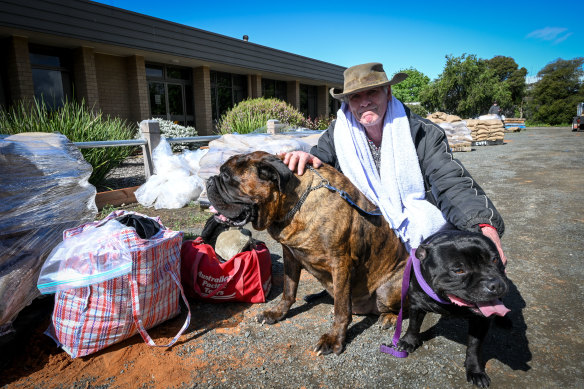
Murchison resident Troy Leay and his two dogs had to be evacuated from their home.Credit:Eddie Jim
Everything else he owns at the five-acre property he lives in on banks of the Goulburn River was marooned on a shrinking island now, inside a house he says is uninsured, where water was almost lapping at his front door.
As he left, transported to safety on an SES boat, he watched brown snakes slither away from the rising floodwaters towards his house.
“I feel distraught,” Leay said.
“I’m going to lose my house.”
A resident of Murchison for the past 10 years, Leay had never experienced a flood here.
He said the water rose frighteningly quickly. His two horses were still stranded there.
“I need to get them water, they can’t drink all this,” he said.
He had no idea when he’d be able to return home, or how much damage he’d find.
By 3pm, the Goulburn River had risen to a height of almost 10.5 metres in Murchison, a small town south of Shepparton, the cusp of major flood level but still well below the record height of 12.22 metres recorded in 1916.
Houses on the eastern side of the bridge had already gone underwater, as had the caravan park.
Locals were frantically sandbagging the shopfronts and the drains on the main street, and authorities were preparing to close the bridge over the swollen river.
About 100 residents had been ordered to evacuate, the town’s SES unit controller, Stephen Addison, said.
Some had made the journey to the Shepparton Showgrounds, but others, such as Leay, had no transport and no designated shelter in town.
Addison said they were still trying to set up an evacuation shelter in town.
“I don’t know many people in Murchison, but I know people will help me; that’s what small towns are like,” Leay said.
Outside the police station, about 30 men from the Australian Defence Force, CFA and Forest Fire Management Victoria were shovelling truckloads of fresh sand into bags to fortify the town.
Addison said the river was expected to peak at 5pm, at a height last seen in the 1970s.
The SES had already completed four rescues by boat, delivering people whose houses had been surrounded by water to safety.
https://news.google.com/__i/rss/rd/articles/CBMixAFodHRwczovL3d3dy50aGVhZ2UuY29tLmF1L25hdGlvbmFsL3ZpY3RvcmlhL3ZpY3Rvcmlhbi13ZWF0aGVyLWxpdmUtdXBkYXRlcy10aG91c2FuZHMtb3JkZXJlZC10by1ldmFjdWF0ZS1zZXMtd2FybmluZ3MtcG93ZXItb3V0YWdlcy1yZW1haW4tYXMtZmxvb2RpbmctaGVhdnktcmFpbi1iYXR0ZXJzLXN0YXRlLTIwMjIxMDEzLXA1YnBuNy5odG1s0gHEAWh0dHBzOi8vYW1wLnRoZWFnZS5jb20uYXUvbmF0aW9uYWwvdmljdG9yaWEvdmljdG9yaWFuLXdlYXRoZXItbGl2ZS11cGRhdGVzLXRob3VzYW5kcy1vcmRlcmVkLXRvLWV2YWN1YXRlLXNlcy13YXJuaW5ncy1wb3dlci1vdXRhZ2VzLXJlbWFpbi1hcy1mbG9vZGluZy1oZWF2eS1yYWluLWJhdHRlcnMtc3RhdGUtMjAyMjEwMTMtcDVicG43Lmh0bWw?oc=5
2022-10-14 09:22:32Z
1603526963
Bagikan Berita Ini


0 Response to "Victorian weather LIVE updates: Thousands ordered to evacuate; SES warnings; power outages remain as flooding, heavy rain batters state - The Age"
Post a Comment