Key posts
Cyclone looms just kilometres off Kalbarri coast
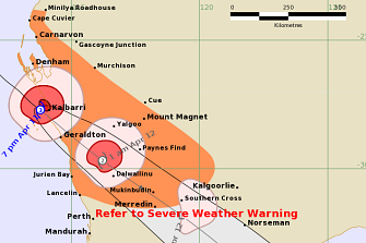
Tropical Cyclone Seroja is looming off the Kalbarri coast, with the latest Bureau of Meteorology advice warning the system is bound south-west at a pace of about 50km/h.
“Impacts are occurring about the coast between Denham and Geraldton, and conditions will deteriorate further during this evening,” the advice warned.

Tropical Cyclone Seroja as of 7pm on Sunday.Credit:Bureau of Meteorology
Seroja has maintained its strength as a category 3 system, but is predicted to weaken as it moves inland later this evening.
Very destructive winds with gusts of up to 170km/h are predicted for Kalbarri, which is almost directly in the storm system’s path, while communities including Geraldton and potentially as far inland as Morawa have been urged to prepare for destructive winds with gusts of up to 150km/h.
There are also warnings of abnormally large tides causing inundation at the coast between Coral Bay and Lancelin, and serious flooding in the Denham and Shark Bay region and near Kalbarri.
“Dangerous surf and beach erosion is expected between Denham and Geraldton,” the BoM warned.
A cyclone red alert is in place for those south of Carnarvon to Lancelin, including the shires of Shark Bay, Northampton, Chapman Valley, Morawa, City of Greater Geraldton, Mingenew, Three Springs, Perenjori, Irwin the townsites of Coorow and Carnamah in the Midwest Gascoyne.
Mid West communities brace for Seroja’s impact
There are fears thousands of homes could suffer severe damage as Cyclone Seroja sweeps in from the Indian Ocean.
Power out in Kalbarri
Nine News Perth reporter Darius Winterfield, on the scene in Kalbarri, has just reported power has gone out in the coastal town.
Winterfield said there was no internet, and many had to resort to 3G coverage as the cyclone barrelled towards the coast.
Western Power reported power outages in Kalbarri and the surrounding areas, which lie almost directly in the path of Tropical Cyclone Serojoa.
As of 6pm AWST, the category 3 system was about 85 kilometres west/north-west of Kalbarri and on track to cross the coast at the same severe strength.
The Bureau of Meteorology predicted winds with gusts of up to 170km/h could hit Kalbarri as the cyclone moved ashore.
Kalbarri State Emergency Service earlier this evening warned power outages were expected soon and urged residents to brace for impact around 8pm.
The system is predicted to make landfall just south of Kalbarri.
Seroja maintains intensity, likely to be category three when it makes landfall
By Daile Cross
Though it had been thought that tropical cyclone Seroja would reduce in severity from a category 3 cyclone to category 2 before making landfall, the latest advice shows it has instead maintained its intensity over the past few hours and will likely remain category three when it passes over land.
A category 3 cyclone usually means a high risk of roof and structural damage and power failures.
A cyclone at this category will have very destructive winds with typical gusts over open flat land of 165-224 kilometres per hour.
The highest level of cyclone is category 5, which means widespread destruction and gusts to 280 kilometres per hour.
WATCH LIVE: The cyclone approaches the coast
Geraldton gets ready for destructive winds
By Daile Cross
There are reports of power outages in Geraldton already, with the cyclone’s most destructive winds expected to hit the town at about 9pm.
It is highly unusual for a cylone to reach as far south as Geraldton.
People near Geraldton may see gales as early as 6pm WST and are likely to experience a brief period of destructive winds around 9pm. The Department of Fire and Emergency Services said if the cyclone’s track shifts a little south from the current forecast, Geraldton would experience a longer period of more intense winds.
Dangerous weather imminent as Seroja closes in on coast
By Daile Cross
The Bureau of Meteorology has issued a new warning for people on the coast between Carnarvon and Lancelin, with a period of dangerous weather now imminent and the cyclone moving very quickly at about 45km/h.
The impact zone is expected to extend inland across areas of the southern Gascoyne and Central Wheatbelt overnight.
Coastal and island communities in the cyclone’s path can expect a period of unusually high tides, destructive winds and intense rainfall, the BoM said.
Seroja is expected to cross the coast between 7pm and 10pm (WST), most likely between the towns of Kalbarri and Geraldton.
Shark Bay is now experiencing damaging wind gusts.
Gusts of up to 165 kilometres per hour are being experienced near the centre of the cyclone. Wind gusts of this strength are very rare for the Central West coast.
The worst conditions at any one location are expected to last around three hours.
Kalbarri locals worry as no evacuation centre available
By Lauren Pilat
A category three cyclone heading their way is a major concern for people in the tourist town of Kalbarri because buildings in the area are not made to the standard to withstand a cyclone.
Kalbarri SES manager Steve Cable said there were no safe buildings able to withstand the damaging winds that Seroja was expected to bring from 4pm Sunday.
Mr Cable, who used to run the Karratha SES unit said further north a similar cyclone wouldn’t be much concern but in Kalbarri it was different.

Gusts are expected to hit from around 4pm.
“A category 2 up north wouldn’t be a big concern but down here it’s a major concern, let alone a category 3, because the buildings aren’t built for it so what’s going to happen, I can’t tell you,” he said.
“It’s a case of now waiting to see if we wear the bullet or not … we can’t do anything now but wait.”
Residents have aired their frustration about no appropriate evacuation centre being available for them.
“There’s a fair bit of frustration among the people, it was a decision made by the people who look after the cyclone emergency centres because putting people in a building that isn’t sufficiently rated would be deemed unsafe,” Mr Cable said.
“That’s left us with no evacuation centre, until the aftermath, which will be for people who are basically homeless. It’s something that needs addressing for the future.”
Kalbarri is expected to be hit by severe winds from 8pm, with the cyclone crossing the area at about 11pm.
“It’s moving fairly quickly so we would estimate between 2-3am the majority of the cyclone would be gone,” he said. “We’ll then be dealing with whatever the aftermath, whatever that happens to be.”
‘Don’t even think about coming out until tomorrow’
By Emma Young
“Weather conditions will deteriorate rapidly for people in the path of the cyclone,” BoM’s James Ashby said.
The peak would last for about three hours.
As this type of weather event had not occurred for decades, there was increased risk for unprepared communities.
He said people in the red alert area must stay inside and activate their emergency plan.
Now was the time to make sure the emergency kit was ready.
For the next five or six hours, an AM radio would be crucial as the internet and phones may not work.
From 4pm impacts will begin in the red alert area.
Do not risk your life by driving into flooded areas.
Emergency Management Australia liaison officers will be arriving tomorrow with aircraft in Exmouth from tomorrow.
But it may not be until mid-tomorrow that authorities would know what damage has occurred.
Police Commissioner Chris Dawson said: “Now we need that assistance from the community. Stay inside tonight. Don’t even think about coming out until tomorrow. And make sure you are listening to that AM radio with batteries.
“Ensure you do not move while this state of emergency is current.”
He said one person had already lost a life yesterday in Coral Bay from an incident with a downed power pole.
WATCH: Water creeps close, butterflies escape as cyclone bears down
By Emma Young
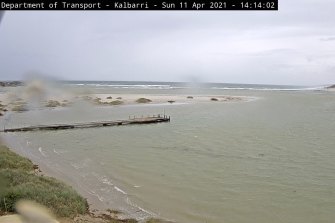
An odd stream of butterflies has emerged in Monkey Mia as locals wait and watch for Cyclone Seroja to make landfall in half an hour, and the ocean laps at their doorsteps.
The local providing WAtoday with this footage said he had never seen anything like this number or variety of butterflies before.
Most Viewed in National
https://news.google.com/__i/rss/rd/articles/CBMigwFodHRwczovL3d3dy5zbWguY29tLmF1L25hdGlvbmFsL3JlZC1hbGVydC1pc3N1ZWQtYXMtdHJvcGljYWwtY3ljbG9uZS1zZXJvamEtdGhyZWF0LWxvb21zLW9mZi13ZXN0ZXJuLWF1c3RyYWxpYS0yMDIxMDQxMS1wNTdpOWUuaHRtbNIBgwFodHRwczovL2FtcC5zbWguY29tLmF1L25hdGlvbmFsL3JlZC1hbGVydC1pc3N1ZWQtYXMtdHJvcGljYWwtY3ljbG9uZS1zZXJvamEtdGhyZWF0LWxvb21zLW9mZi13ZXN0ZXJuLWF1c3RyYWxpYS0yMDIxMDQxMS1wNTdpOWUuaHRtbA?oc=5
2021-04-11 11:18:50Z
52781502573070
Bagikan Berita Ini


0 Response to "Dangerous weather imminent as tropical cyclone Seroja approaches WA coast - The Sydney Morning Herald"
Post a Comment